

For Agents & Listing Coordinators
MLS-Ready Listing Images
No Drone Required
Just point to any parcel in the US.
We deliver a complete set of pro quality unbranded listing images with parcel lines.
Delivered in 24 hours. Packages start at $99.
Already have an account?

How it Works (3 Steps)
Standout Listing in 3 Steps
Step 1
Select the Subject Property
We generate five high-resolution images — each with clean parcel boundaries, framed at different zoom levels and angles for maximum impact.
Step 2
We Build Your Visual Kit
We generate five high-resolution images — each with clean parcel boundaries, framed at different zoom levels and angles for maximum impact.
Step 3
You Use It to Create a Standout Listing
Upload the unbranded image to your MLS. Post the branded version to social. Add them to flyers, emails, or a seller update.
Here’s What’s Included
Our commitment to delivering reliable solutions on time and within budget sets us apart, creating long-lasting partnerships built on trust and success.
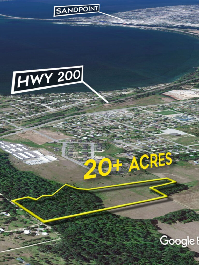
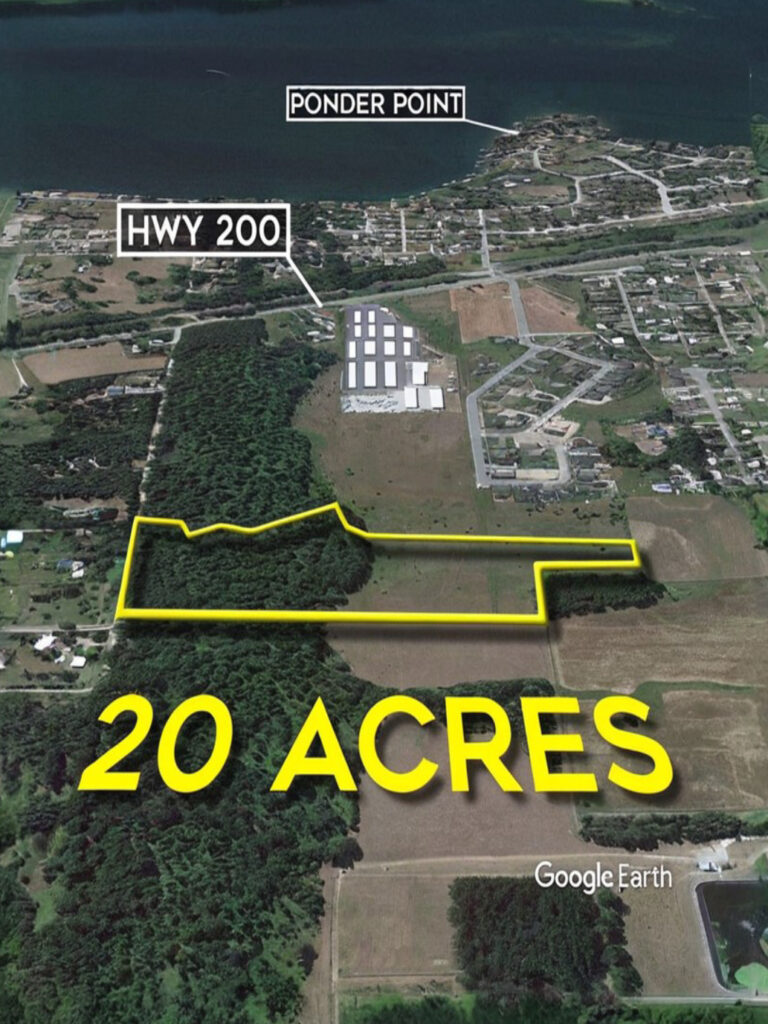
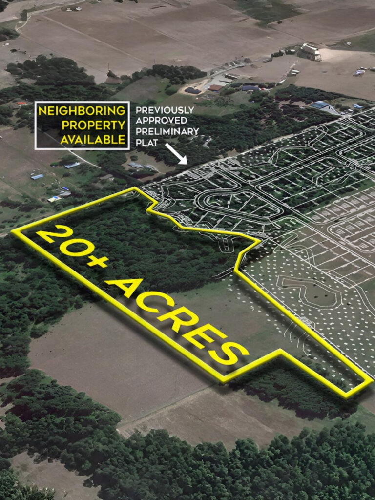
High-Resolution Map Images (5 total)
You get five polished, geo-aligned images with parcel boundaries — delivered in multiple zoom levels and angles.
Includes Both Branded & Un-Branded Images
- Unbranded images for MLS compliance
- Branded images with your name/logo for flyers, posts, and seller updates
Buyer Persona Snapshot
- The likely buyer type(s)
- Suggested talking points for calls or showings
- Keyword themes for social/media targeting
Optimized Listing Description
A short, compelling listing description tailored for land. Clean, structured, and optimized for both humans and MLS input fields.
Still trying to draw lines on Google Maps?
Find everything you need to grow and scale your business in one place. Our mission is to transform ideas into innovative technology that makes a difference.
Find out what clients are
saying about us.
★★★★★
This team of designers and developers is my go-to for all my web development projects. We’ve been working together for the past couple of years and have successfully collaborated and completed multiple projects.
Sarah James
@sarah
★★★★★
Developing our cross-platform application and the multiple integrations was made possible thanks to this amazing team and their dedication. Right from the user experience to the functionality, the approach taken is truly commendable
Jaheim Philip
@philip
★★★★★
The website migration and database optimizations that followed truly enhanced the experience for our users. They successfully migrated all the data to different servers and configured them properly to handle the peak hours.
Cody Fisher
@fisher
★★★★★
Their excellent content strategy ticked all the right boxes and allowed us to connect strongly with a wider audience effectively. The content strategy is a blend of storytelling with the best SEO practices that yield the best results.
Ronald Richards
@ronald
Choosing the Right Pictures for Land & Lot Listings
Map Graphics, Drone Photos or Regular Photos
| Scenario | Map Graphics | Drone Photos | Regular Photos | Why Use Ours |
|---|---|---|---|---|
| 🏜️ Large vacant parcels | ✅ | ❌ | ❌ | Only our maps show full property + surrounding context in one shot. |
| 💰 Low-budget listings | ✅ | ❌ | ✅ | Cheaper than drone, clearer than ground-level pics. |
| 🕐 Need visuals fast | ✅ | ❌ | ✅ | We deliver in hours — faster than scheduling drone or pro photography. |
| 🛑 Restricted airspace / weather issues | ✅ | ❌ | ✅ | No weather or FAA delays — ready anytime. |
| 🏞️ Remote, hard-to-access land | ✅ | ❌ | ❌ | You don’t need to visit — we generate everything remotely. |
| 🗺️ Location, access, and boundary clarity | ✅ | ➖ | ❌ | We overlay roads, easements, landmarks, parcel lines. |
| 📦 You’re handling multiple lots | ✅ | ❌ | ✅ | We scale — no site visits, no scheduling. Great for land portfolios. |
| 🤝 Trying to impress seller | ✅ | ✅ | ✅ | Professional maps show you have a plan. Not just pics — strategy. |
| 🏡 Premium residential listing | ✅ | ✅ | ✅ | Use all 3: Drone = vibe, Map = clarity, Photos = detail. |
| 🔎 Out-of-area buyers | ✅ | ✅ | ❌ | Maps + aerials help buyers see terrain + access clearly. |
| 📱 Need MLS/social-ready assets | ✅ | ❌ | ✅ | Our files are cropped and sized for MLS & social. No edits needed. |


Explore our
Knowledge Base.


We love hearing from you.
We Should Hang Out

Frequently asked questions
Will this work for my MLS?
Yes — we deliver unbranded images in the correct aspect ratio and resolution. No logos, no calls to action, no text overlays. It’s ready for direct upload.
What if I don’t have the parcel boundaries?
No problem — just drop a pin or paste a link to the property (listing, county GIS, Google Maps, etc.). We’ll take it from there and map it accurately.
Can I get revisions?
Absolutely — if something looks off or you want a tweak, we’ll make it right. One round of revision is included free.
How fast will I get everything?
Usually within 24 hours — often sooner. We’ll email you as soon as it’s ready.
Do I have to subscribe or create an account?
No subscriptions. No accounts. No tools to learn. You order, we deliver.